
Ted Wynn, Bulloch County Public Safety/EMA/HS Director released an update on Tuesday, November 8, 2022 for Tropical Storm Nicole from Will Lanxton, Meteorologist for GEMA/HS.
Bulloch Potentially Impacted by Inland Winds & Rainfall
Across inland Georgia, wind gusts of 25-40 mph are possible ahead of the system on Wednesday night and could increase to 30-50 mph for Thursday through Thursday night. Gusty winds could linger on the backside of the system as it moves out on Friday. The heavy rainfall threat and most of the rainfall accumulation will occur on the eastern side of Nicole as it moves through Georgia. Parts of eastern and southeastern Georgia could receive 2-4 inches of total rainfall, with higher amounts possible along the coast. Areas further inland across Georgia should receive 2 inches of rain or less. Because the system is forecast to move so quickly through Georgia, the threat for inland/flash flooding is not expected to be significant.
Changes since yesterday:
• Nicole transitioned from a subtropical to a tropical system this morning and is now Tropical Storm Nicole. This was expected and does not change the forecast impacts. Nicole’s wind field will remain large, leading to coastal impacts well ahead of the system and strong winds extending far from the center as it moves through Georgia.
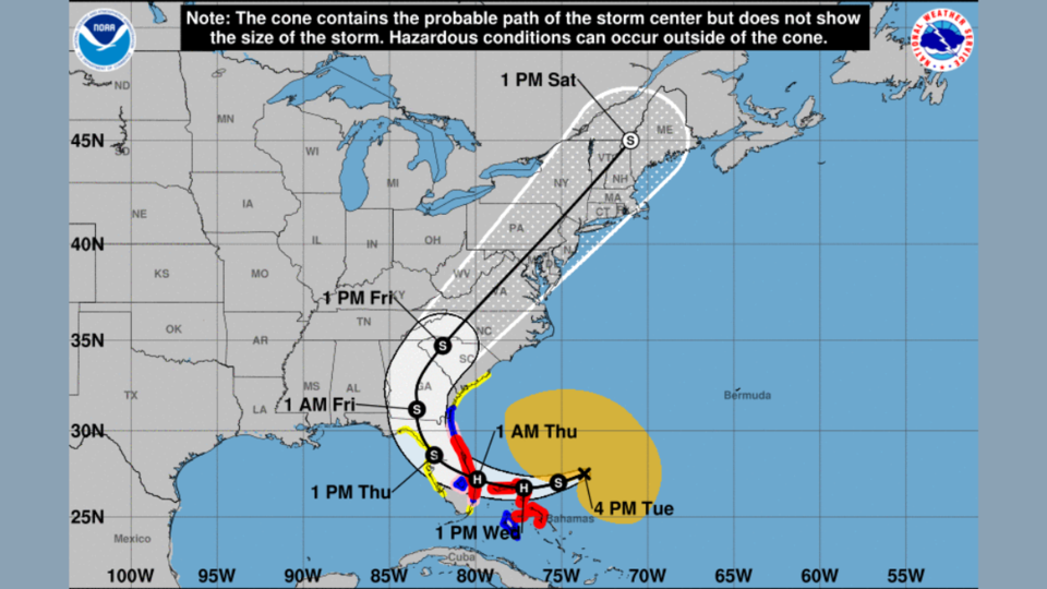
• Nicole’s forecast path from NHC now takes a more gradual turn. The timeline has sped up by approximately 12 hours and the center of the storm is now forecast to move farther west and north through Georgia. This now brings the threat for gusty winds and heavy rainfall farther inland across Georgia for Thursday afternoon through Friday evening.
Timing
Nicole is forecast to make landfall as a low-end Category 1 hurricane along the east coast of Florida on Wednesday night and Thursday morning. It will quickly weaken back to tropical storm status as it turns northward. Direct impacts from heavier bands could begin in southern Georgia by late Thursday morning. The storm will continue to overspread Georgia throughout Thursday, turning to the northeast overnight, and exiting eastern Georgia by Friday afternoon/evening.
Coastal Impacts
Strong onshore flow formed by the interaction of Tropical Storm Nicole and a strong high-pressure system over the Northeast U.S. will start to produce indirect impacts along the coast of Georgia today, particularly around the time of already high astronomical tides. Moderate coastal flooding, significant beach erosion, life-threatening rip currents, and dangerous sea and surf conditions will all be possible along the entire Georgia coast today through Friday.
Watches & Warnings
• For Coastal Camden and Glynn Counties: A Tropical Storm Warning and a Storm Surge Warning have been issued. 35-45 mph sustained winds with gusts to 55 mph are possible between early Thursday morning and early Friday morning. Additionally, there is the potential for 3-5 feet of storm surge above ground level within surge prone areas beginning with today’s high tides and continuing through Friday evening. This qualifies as life-threatening storm surge inundation potential.
• For Coastal McIntosh, Liberty, Bryan, and Chatham Counties: A Tropical Storm Watch and a Storm Surge Watch have been issued. 35-45 mph sustained winds with gusts to 55 mph are possible between early Thursday morning and early Friday morning. Additionally, there is the potential for 2-4 feet of storm surge above ground level within surge prone areas beginning with today’s high tides and continuing through Friday evening.
• For Inland Coastal Georgia Counties: A Tropical Storm Watch has been issued for inland portions of Camden, Glynn, McIntosh, Liberty, Bryan, and Chatham Counties. 30-40 mph sustained winds with gusts to 55 mph are possible Thursday evening through early Friday morning.
Tornadoes
The overall tornado threat is expected to be low and confined to a line east of Augusta to Dublin to Valdosta. The Storm Prediction Center has outlined this area in a Marginal Risk (level 1 of 5) for tornadoes on Thursday through Friday morning. Any tornadoes that do spin up would likely be weak and short-lived.
Confidence is high for coastal impacts and increasing for inland impacts. Please continue to monitor forecast updates from the National Hurricane Center, your local National Weather Service office, and reliable media outlets throughout the event.


