
The Grice Connect team has spent the last few days gathering and distributing information on Tropical Storm Debby. As TS Debby continues to leave her mark on Bulloch County flooding and washed out roads have become a significant issue.
NWS Charleston is predicting an additional 4 to 6 inches for rain through Friday. With this in mind we have created this guide with helpful information to assist all of us recover from TS Debby.
A huge shout out to all of our law enforcement, paramedics, firefighters and public works who are working tirelessly throughout TS Debby response monitoring roadways, helping clear roads and responding to emergency calls. They are toting a huge load for all of us.
If you see water covering the roadway
- Turn around, don't drown when encountering flooded roads. Most flood deaths occur in vehicles.
- Be especially cautious at night when it is harder to recognize the dangers of flooding.
- Be aware of your surroundings and do not drive on flooded roads.
CLICK HERE for current weather conditions and weather alerts
Click Here for business closings
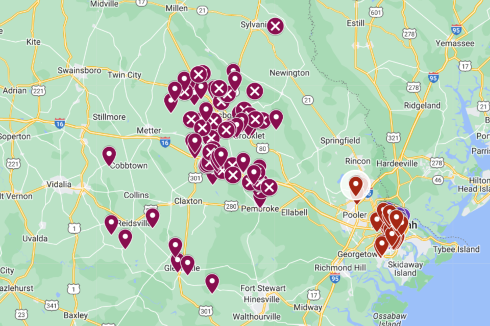
Road Closures
We have put together an interactive map of road closures to help keep you informed. Keep in mind that this map is primarily relying on information from readers and conditions are changing rapidly. It is the best we can offer, it will not be perfect, but hopefully it will he helpful. We have included Savannah and some surrounding areas where folks are traveling to or from for work.
Special thanks to Edie Grice and Zamaria Ball with the GS Institute for Vibrant and Engaged Communities for their assistance in creating the interactive map and helping us keep it updated. Thanks to each of you for contributing pictures and information as well. Together you are all making a difference for so many.
We are doing our best to keep up with the closures. However as you can see there are issues countywide. Please limit travel to major roads if possible. Accuracy of map is limited to feedback from residents and local officials. Conditions may change rapidly before we can update. The goal of the map is to show citizens how challenging the roads are.
DO NOT DRIVE AROUND ROAD CLOSED SIGNS!
If you have firsthand knowledge of a road that is closed and not on the map above or that has been reopened please register it on the form below.
Share your flood images in the comments on the post below on GriceConnect's Facebook Page. You can also go to that post to view the significant flooding occurring throughout the county along with storm damage.
If you know firsthand of a blocked or washed out road, PLEASE either:
- Direct Message Bulloch County Public Safety and EMA on Faceboook the location - road name and an intersection or some locator on that road, or
- Call Bulloch County Public Works at 912-764-6369 to make a report.
This will help them keep the list current and get the info to crews who are responding as quickly as they safely can.
MAJOR flooding is predicted for the Ogeechee River at Eden with predictions to crest early Saturday morning at 16 feet.
Dams Breached
Simmons Pond
Both dams at Simmons Pond have breached. All residents near the pond or downstream are STRONGLY ENCOURAGED to seek shelter away from this area - and avoid this portion of Hwy 46 as the water is expected to rise further over the next few days before it begins to drop. A voluntary evacuation of this area has been issued.
Qattlebaum Pond (Potential)
There is a potential dam breach of Quattlebaum Pond. All residents near the pond or down stream should be aware of fast rising water in this area. Seek higher ground if needed.
Ricklighter Pond (Potential)
There is a potential dam breach of Ricklighter Pond. The area of Shuman Road, Maria Sorell Road, Old River Road North and R. L. Lee Road could be affected.
Oglesby Pond
Oglesby Pond dam has breached. The water will travel down Lotts Creek to Highway 80. The water will travel to Lake Collins as well. Cypress Lake is in the path.
Power Outages
To view power outages
Key Websites
Here are a few key websites that will may be helpful to you as the storm progresses:
Grice Connect FB Page (we update rapidly changing weather conditions quickly on our Facebook page. Make sure to like and follow)
Georgia Power (GPC) Outage Map
Excelsior EMC (EMC) Outage Map
To request assistance for non-emergency incidents, like a tree or water covering the roadway PLEASE DO NOT CALL 911. 911 should be reserved for life or death emergencies especially in potential high call volume incidents.
Statesboro Police Department Non-Emergency number -912-764-9911
Bulloch County Sheriffs Office Non-Emergency number - 912-764-8888
Code Red Alert
The City of Statesboro and Bulloch County announced a partnership to implement the CodeRED system, a high-speed emergency notification service provided by OnSolve, based in Ormond Beach, Florida. Public safety officials across the United States have credited CodeRED notifications for saving lives, including locating missing children, apprehending wanted criminals, and issuing timely evacuations.
Click here to add this to your phone now.
Be Alert
Be ready to take action should severe weather develop. Stay tuned to NOAA Weather Radio, Grice Connect, Bulloch County EMA, TV or your local news source for the latest information from the National Weather Service.
Click here for updated weather information throughout the day.


