
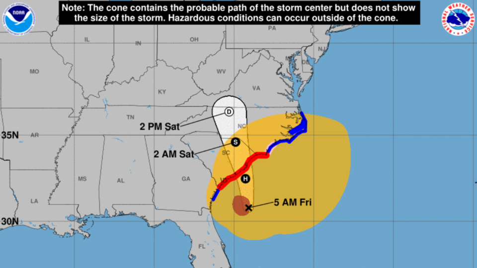
The 5 AM NHC advisory on Friday, September 30, 2022, Hurricane Ian is still at sea heading toward South Carolina as a Cat 1 hurricane with sustained wind speeds of 85 mph.
After a relatively quiet night with some wind gusts, Bulloch County residents are waking up to an upgraded Tropical Storm Warning from the previous Tropical Storm Watch. This means wind gust could be higher than first anticipated. NWS is predicting sustained wind of 15-25 mph with gust up to 40 mph.
Bulloch County Impact
We have been upgraded to a tropical storm warning in Bulloch County and while the projected path has shifted a little more east, we should still stay prepared for sustained winds of 15 to 25 mph with the possibility of winds gusts of tropical storm force strength up to 40 mph.
It appears that the worse wind gusts will be before noon, but high winds and gusts will continue until early evening.
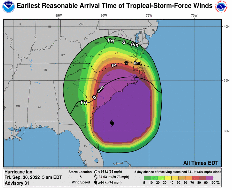
S: Tropical Storm – wind speed between 39 MPH and 73 MPH
Stay safe and keep informed.
Call Non Emergency Numbers to Report Down Trees
Bulloch County Public works crews have worked throughout the day removing several trees from different roadways. You can report trees down by calling the BCSO at 912-764-8888 or Bulloch EMA/Public Safety at 912-489-1661 extension 1/Communications Center. For emergencies dial 911. Be safe and monitor the storm.
Tropical Storm Watch remains in effect on Thursday, September 29 by NWS Charleston. A Tropical Storm Watch means tropical storm-force winds are possible somewhere within this area within the next 24 hours.
Statesboro-Bulloch Airport Wind Speeds
Winds picked up overnight across Bulloch County. The Statesboro-Bulloch Airport reported sustained winds at 12 mph overnight and gusts over 23 mph. The NWS Charleston is predicting sustained winds to increase to over 15-25 mph with gusts to 40 mph throughout the day on Friday.
Public Safety Response Overnight
Statesboro and Bulloch County public safety agencies continue to respond to reports of trees down.
Prepare for Power Outages
Now is the time to prepare for power outages. Fully charge all of your electronic devices. Have your generators filled with fuel and make any other preparations you need to be without power for an extended period of time. We are not anticipating long term outages here, but it is best to follow their lead and be as prepared as possible.
Power Outage Reports
Bulloch County Public Works have been responding all day and evening to down trees. We have experienced some isolated power outages related to these trees. You can CLICK HERE to check a summary of current power outage status for Bulloch County.
As of 5:30 am on Thursday there are 13 reported power outages in Bulloch County.
To check power outages by company or to report outages see below:
CLICK HERE for Georgia Power or view below
Call Georgia Power at 1-888-891-0938 or 911 to report downed power lines.
Click Here for Excelsior EMC Outage Map
To report an outage with Excelsior call 912-685-2115 or 912-764-2123
EMC has a mobile app you can download below:
Download the EMC Mobile App
Apple Devices
Google Play Store
Tropical Storm Warning
A Tropical Storm Warning means tropical storm-force winds are expected somewhere within this area within the next few hours.
* LOCATIONS AFFECTED
- Statesboro
- Portal
- Denmark
* WIND
- LATEST LOCAL FORECAST: Tropical storm force winds remain possible
- Peak Wind Forecast: 15-25 mph with gusts to 40 mph
- THREAT TO LIFE AND PROPERTY THAT INCLUDES TYPICAL FORECAST
UNCERTAINTY IN TRACK, SIZE AND INTENSITY: Potential for wind 39 to 57 mph
- The wind threat has remained nearly steady from the previous assessment.
- PLAN: Plan for hazardous wind of equivalent tropical storm force.
- PREPARE: Remaining efforts to protect property should be completed as soon as possible. Prepare for limited wind damage.
- ACT: Move to safe shelter before the wind becomes hazardous.
- POTENTIAL IMPACTS: Limited
- Damage to porches, awnings, carports, sheds, and unanchored mobile homes. Unsecured lightweight objects blown about.
- Large tree limbs broken off. A few trees snapped our uprooted, but with greater numbers in places where tree are shallow rooted.
- Some roads impassable due to debris, particularly within urban or heavily wooded locations. Hazardous drivig conditions on bridges and other elevated roadways especially for high profile vehicles.
- Isolated to scattered power and communications outages.
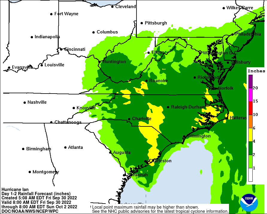
* FLOODING RAIN
- LATEST LOCAL FORECAST:
- Peak Rainfall Amounts: No additional significant rainfall forecast
- THREAT TO LIFE AND PROPERTY THAT INCLUDES TYPICAL FORECAST UNCERTAINTY IN TRACK, SIZE AND INTENSITY: Potential for localized flooding rain
- The flooding rain threat has remained nearly steady from the previous assessment.
- PLAN: Emergency plans should include the potential for localized flooding from heavy rain.
- PREPARE: Consider protective actions if you are in an area vulnerable to flooding.
- ACT: Heed any flood watches and warnings.
- POTENTIAL FLOODING IMPACTS: Limited
- Localized rainfall flooding could prompt a few rescues.
- Rivers and tributaries could quickly rise with swifter currents. Small streams, creeks, canals, and ditches could become swollen and overflow in spots.
- Flood waters can enter a few structures, especially in normally vulnerable spots. Rapid ponding of water could occur at underpasses, low-lying spots, and poor drainage areas. Several storm drains and retention ponds become near-full and begin to overflow. Some brief road and bride closures.
* TORNADO
- LATEST LOCAL FORECAST:
- Situation is unfavorable for tornadoes
- THREAT TO LIFE AND PROPERTY THAT INCLUDES TYPICAL FORECAST UNCERTAINTY IN TRACK, SIZE AND INTENSITY: Tornadoes not expected
- The tornado threat has remained nearly steady from the previous assessment.
- PLAN: Tornadoes are not expected. Showers and thunderstorms with gusty winds may still occur.
- PREPARE: Little to no preparations needed to protect against tornadoes at this time. Keep informed of the latest tornado situation.
- ACT: Listen for changes in the forecast.
- POTENTIAL IMPACTS: Little to None
- Little to no potential impacts from tornadoes.
Florida Impacts
As expected many parts of Florida have been devastated by Hurricane Ian. As of 5:30 AM there are over still over 2 million Floridians without power. Ian came ashore as a massive 150 mph hurricane. Storm surge has been reported to be as high as 12 feet engulfing homes and cars along the coast and trapping some people in their homes.
How Best to Help Florida
The most important thing to focus on is you and your family's safety over the next 48 hours. Once the storm has passed our area and we are clear none of our friends or neighbors need help or assistance we as a community can shift our focus on others who need help.
26 states have already offered help and FEMA has staged millions of meals and water to deploy to the worst hit areas as soon as the storm subsides. The best way to help immediate is to contribute financially to one of the many agencies who will be responding to help. This will be a very long recovery effort in helping them rebuild and there will be many opportunities to help.
DO NOT SELF DEPLOY TO FLORIDA OR START COLLECTING ITEMS TO SEND TO FLORIDA
Bulloch County VOAD has been monitoring and preparing to address the immediate needs in Bulloch County. They also have a team who have already joined briefings on preparations to assist Florida.
Florida officials have been very clear on these briefing calls in asking the public not to self deploy to Florida and they do not want random supplies shipped to communities have been devastated. A large influx of used clothes, water and other items that philanthropic citizens assume is needed creates a secondary disaster in managing all of these incoming supplies.
The best way to help is to support major national charities financially who are responding like Red Cross, Salvation Army and many others who are trained and prepared to respond to meet individual needs in times of disaster.
Florida officials will work to rapidly get a list of needs distributed publicly as material needs arise.
NHC Live Hurricane Ian Updates
Full list of Closings|Cancellations |Reschedules
Click here for list of closings.

Click Here to go to Grice Connect’s HURRICANE WATCH to get updated on all Bulloch County and Statesboro Hurricane IAN information.
Have family and Friends Follow and Subscribe to Grice Connect Now
Now is the time to be thinking about your Hurricane preparation plans which include liking and following Grice Connect on Facebook and subscribing to Grice Connect daily emails so you can keep up with how this storm could impact Statesboro and Bulloch County. Please also share with family and friends so they can keep updated with the storm as well.

For more hyper-local Statesboro, Georgia Southern, and Bulloch County news and events delivered directly to your inbox every day, subscribe to Grice Connect's Bulloch Daily email by clicking here. Totally FREE and ALL LOCAL! Unsubscribe at anytime.


