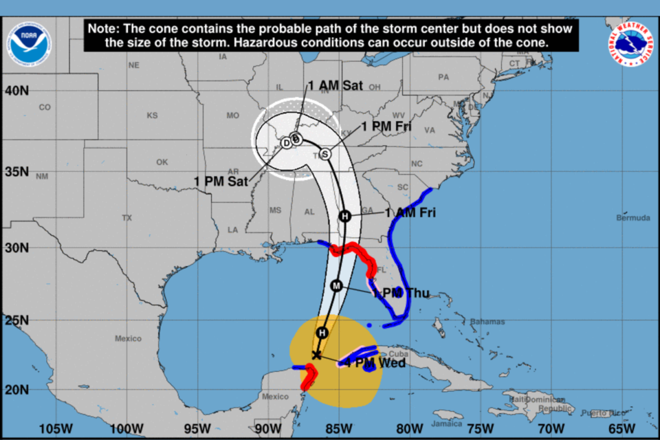
Hurricane Helene path has shifted westward which has lessened rainfall predictions for Bulloch County which are now predicted be less than 2 inches total from 8 pm Wednesday night to 8 pm Friday.
Sustained winds of 20 to 30 mph with gusts up to 55 mph are possible Thursday afternoon through early Friday morning. The biggest concerns at this time are isolated to scattered power outages caused by downed and uprooted trees. Risks for tornados is a concern as well.
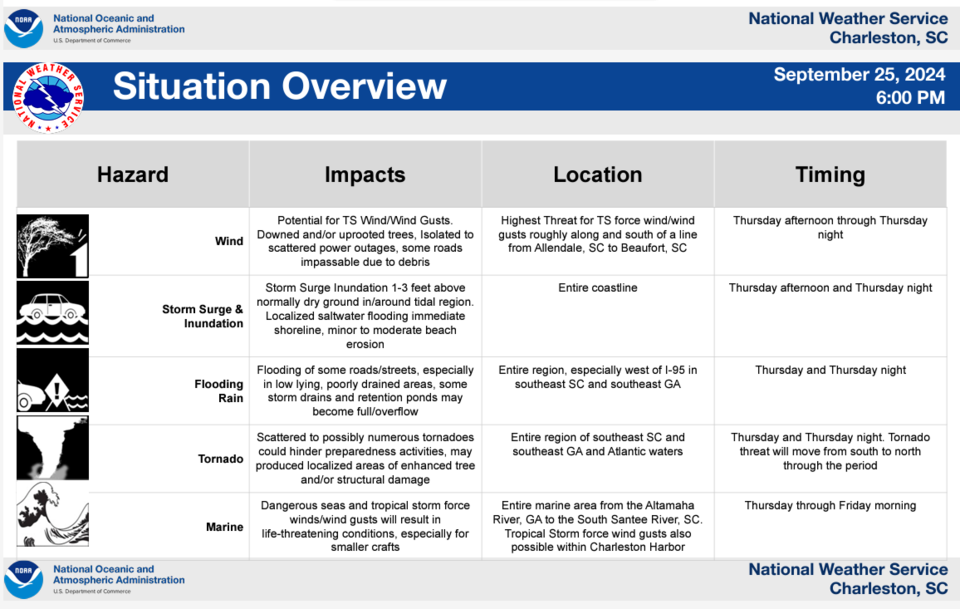
NWS Charleston Situation overview
As of 6 pm on Wednesday evening, Hurricane Helene is expected to intensify into a major hurricane as it moves northward through the eastern Gulf of Mexico by Thursday, September 25, 2024. The storm is projected to make landfall in the Big Bend area of Florida Thursday evening, continuing its path northward through Georgia overnight and into early Friday morning. Helene is forecasted to become a large storm with effects extending far beyond its central track.
There is an increased risk of tornadoes as Helene approaches, with the threat intensifying throughout Thursday and peaking Thursday night into early Friday.
Southeast Georgia and the nearby Atlantic waters will experience tropical storm-force winds of 20 to 30 mph, with frequent gusts ranging from 40 to 60 mph. These winds are expected to begin Thursday evening, expanding into Southeast South Carolina and coastal waters by Thursday night. Wind speeds are likely to peak late Thursday night as Helene's center moves over central Georgia.
Rain bands from the storm will begin impacting Southeast Georgia early Thursday morning, with heavier rain spreading throughout the day and into the night. Rainfall is expected to taper off Friday morning as the storm moves into the southern Appalachian region. Average rainfall totals will range from 1.5 to 3 inches, with higher amounts possible in some areas, particularly west of I-95. Minor flooding in low-lying and poor drainage areas is likely, with isolated flash flooding also possible.
Residents are encouraged to monitor updates and prepare for potential storm impacts, including power outages and localized flooding.

Click here for updated NWS weather forecast.
Bulloch and surrounding counties remain under a Tropical Storm Warning.
Bulloch County Weather Forecast
Wednesday Night
A chance of showers and thunderstorms, then showers likely and possibly a thunderstorm after 4am. Mostly cloudy, with a low around 72. Southeast wind 7 to 10 mph. Chance of precipitation is 60%. New rainfall amounts between a tenth and quarter of an inch, except higher amounts possible in thunderstorms.
Thursday
Showers and possibly a thunderstorm. Some of the storms could produce heavy rainfall. High near 81. East wind 7 to 14 mph, with gusts as high as 28 mph. Chance of precipitation is 100%. New rainfall amounts between three quarters and one inch possible.
Thursday Night
Tropical storm conditions possible. Showers and possibly a thunderstorm. Some of the storms could produce heavy rainfall. Low around 73. Chance of precipitation is 100%. New rainfall amounts between a half and three quarters of an inch possible.
Friday
A 30 percent chance of showers, mainly before 8am. Mostly cloudy, then gradually becoming sunny, with a high near 85. Breezy, with a southwest wind 15 to 21 mph, with gusts as high as 40 mph.
The Grice Connect team will continue monitoring the storm until it has passed. Continue checking back for updates as conditions change.
Be Alert
Be ready to take action should severe weather develop. Stay tuned to NOAA Weather Radio, Grice Connect, Bulloch County EMA, TV or your local news source for the latest information from the National Weather Service.
Click here for updated NWS weather information throughout the day.


