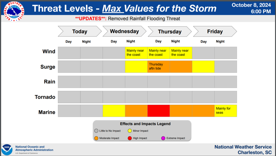
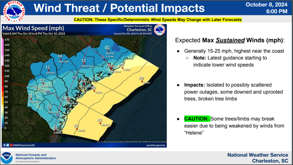
Statesboro hotels are full as thousands evacuate Florida before Hurricane Milton makes landfall. At this time, the NWS predictions for Bulloch County is max sustained winds for 15 to 28 mph with max wind gusts of 32 mph. Bulloch County EMA is continuing to monitor this storm and will provide us updates as conditions may change.
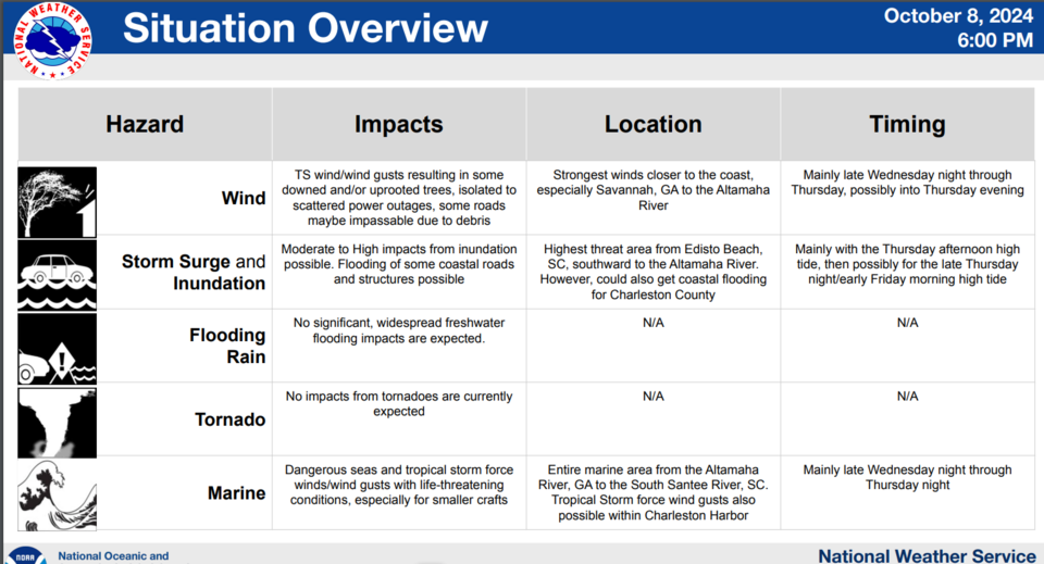
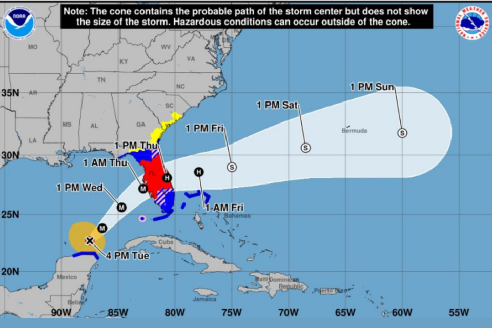
Hurricane Milton is expected to shift east across central Florida Wednesday night into Thursday morning, then continue east over the western Atlantic by Thursday afternoon. Milton is expected to be a large storm with impacts extending well away from the center. Southeast Georgia and the South Carolina Lowcountry could experience several impacts from the passing storm, including windy conditions, high surf, dangerous rip currents, and coastal flooding.
Key Takeaways
- Milton strengthens back to dangerous, Category 5 Hurricane. Additional changes in intensity can be expected through time of landfall across west-central Florida
- The highest impacts of concern: Storm surge inundation, dangerous marine conditions
- The expanse of Milton’s wind field still expected to greatly increase by later Wednesday and Thursday, touching portions of our coastal area and Atlantic waters


Corey Kemp, Director of Bulloch County EMA and Bulloch County VOAD have been working to replenish supply inventory and prepare for Hurricane Milton's potential impacts. Thanks to Excelsior EMC's donation of five truckloads of food and 15 pallets of water, the Statesboro Food Bank is in a very good position in the unexpected event the impacts here are worse than predicted.
Beginning Tuesday night at 8:00 pm Bulloch County EMA staff will be broadcasting updates on Statesboro's radio stations 94.9 and 106.5. These broadcasts will continue at 8:00 am, 2:00 pm and 8:00 pm until Hurricane Milton has passed our area. In the event of a major loss of power and cell services these broadcast will keep you updated on storms impacts and resources available to you.
Once the storm passes if there are major impacts, Bulloch EMA will use Code Red Alert at these times as well to keep citizens updated.
Of course, Grice Connect will be with you every step of the way over the next few days as we have been for every major storm and event in Bulloch County. Click Here for all of our updates.
Bulloch VOAD is working again with partners in Statesboro, Brooklet, Register, Portal, Leefield, Nevils and Stilson communities to provide central points for distribution of supplies and a place to go if you have a specific need and no communication.
Click here for the latest NWS Charleston Bulloch County weather forecast and hazardous condition alerts.
Click here for Bulloch County Public Safety and EMA Facebook updates.
Code Red Alert
The City of Statesboro and Bulloch County announced a partnership to implement the CodeRED system, a high-speed emergency notification service provided by OnSolve, based in Ormond Beach, Florida. Public safety officials across the United States have credited CodeRED notifications for saving lives, including locating missing children, apprehending wanted criminals, and issuing timely evacuations.
Click here to add this to your phone now.
Be Alert
Be ready to take action should severe weather develop. Stay tuned to NOAA Weather Radio, Grice Connect, Bulloch County EMA, TV or your local news source for the latest information from the National Weather Service.
Click here for updated NWS weather information throughout the day.
Stay connected with Grice Connect for continued coverage and updates on the storm and its impact on our region.


