
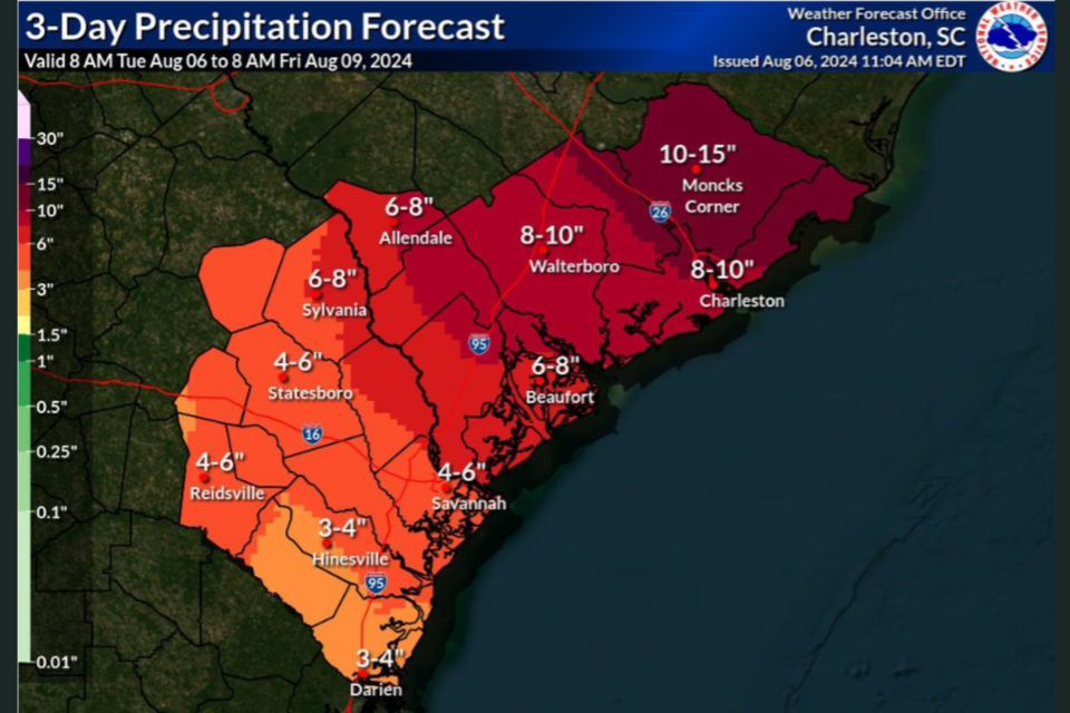
As Tropical Storm Debby pushes through Bulloch County on Tuesday, August 6th flooding and washed our roads have become a significant issue. While the most significant, consistent rains have passed, NWS Charleston is predicting an additional 4 to 6 inches for rain through Friday.
The rain will come as the bands pass and could be heavy at times and include thunderstorms. Flash flood warnings will continue as well.
A huge shout out to all of our law enforcement, paramedics, firefighters and public works who worked tirelessly throughout the night and continuing today monitoring roadways, helping clear roads and responding to emergency calls. They are toting a huge load for all of us.
- Turn around, don't drown when encountering flooded roads. Most flood deaths occur in vehicles.
- Be especially cautious at night when it is harder to recognize the dangers of flooding.
- Be aware of your surroundings and do not drive on flooded roads.
Share your flood images in the comments on the post below on GriceConnect's Facebook Page. You can also go to that post to view the significant flooding occurring throughout the county along with storm damage.
The City of Statesboro has received nearly 7 inches of rain as of Tuesday morning.
Bulloch County rainfall totals as of Tuesday, August 6th
Statesboro 4.4 N 6.70 in 0735 AM 08/06 COCORAHS
Brooklet 1 W 6.25 in 0600 AM 08/06 COOP
Oliver 1 SW 5.57 in 0830 AM 08/06 USGS
Rocky Ford 4.33 in 0900 AM 08/06 USGS
Statesboro 1.32 in 0915 AM 08/06 UGA
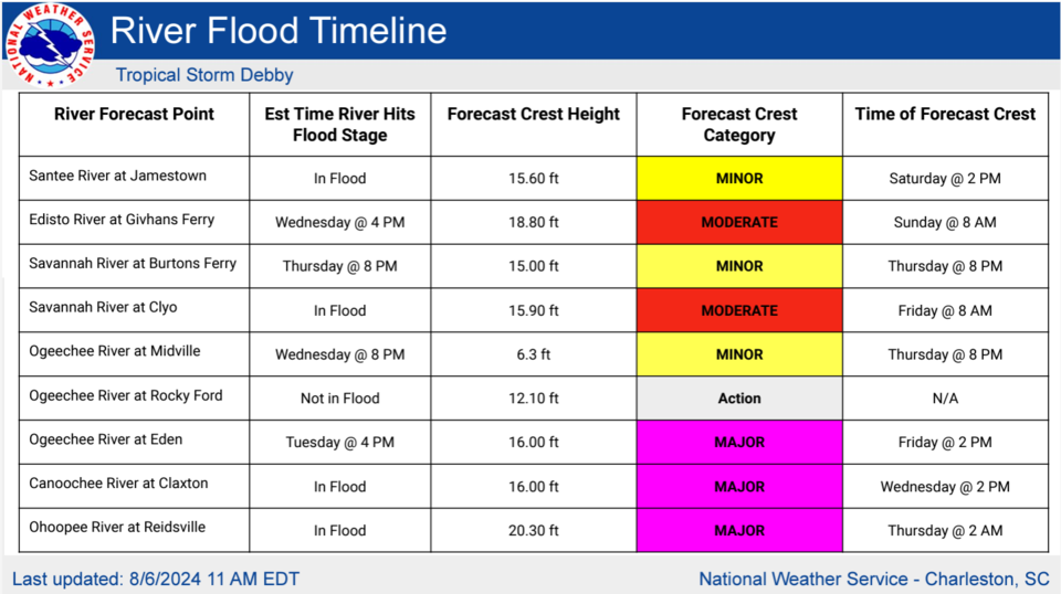
MAJOR flooding is predicted for the Ogeechee River at Eden with predictions to crest at 2 PM on Friday at 16 feet.
Roads Closed
From Bulloch County Public Safety and EMA at 10 AM on August 6th
- Currently 40-50 roads affected (water over the road at some point)
- 50-75 trees across the road (mostly cleared)
- 5 trees on houses
INTERACTIVE MAP of Road Closures
GC's road closed list as of 11 AM Tuesday.
Go to Bulloch County Public Safety and EMA for the most current road closures and hazards list.
If you know firsthand of a blocked or washed out road, PLEASE either:
- Direct Message Bulloch County Public Safety and EMA on Faceboook the location - road name and an intersection or some locator on that road, or
- Call Bulloch County Public Works at 912-764-0124.
This will help them keep the list current and get the info to crews who are responding as quickly as they safely can.
Dams Breached
Simmons Pond
Both dams at Simmons Pond have breached. All residents near the pond or downstream are STRONGLY ENCOURAGED to seek shelter away from this area - and avoid this portion of Hwy 46 as the water is expected to rise further over the next few days before it begins to drop. A voluntary evacuation of this area has been issued.
Qattlebaum Pond (Potential)
There is a potential dam breach of Quattlebaum Pond. All residents near the pond or down stream should be aware of fast rising water in this area. Seek higher ground if needed.
Ricklighter Pond (Potential)
There is a potential dam breach of Ricklighter Pond. The area of Shuman Road, Maria Sorell Road, Old River Road North and R. L. Lee Road could be affected.
Power Outages
Power Outages as of 1:00 PM August 6th
- EMC - 204 - Excelsior EMC (EMC) Outage Map
- GPC - 87 - Georgia Power (GPC) Outage Map
Key Websites
Here are a few key websites that will may be helpful to you as the storm progresses:
Grice Connect FB Page (we update rapidly changing weather conditions quickly on our Facebook page. Make sure to like and follow)
Georgia Power (GPC) Outage Map
Excelsior EMC (EMC) Outage Map
To request assistance for non-emergency incidents, like a tree or water covering the roadway PLEASE DO NOT CALL 911. 911 should be reserved for life or death emergencies especially in potential high call volume incidents.
Statesboro Police Department Non-Emergency number -912-764-9911
Bulloch County Sheriffs Office Non-Emergency number - 912-764-8888
Watches and advisories
- Hazardous Weather Outlook
- Hurricane Local Statement
- Flood Watch until August 9, 08:00 AM EDT
- Tropical Storm Warning
- Flash Flood Warning until August 6, 02:00 PM EDT
CLICK HERE to view the 11 AM 8/6/24 NWS Charleston Hurricane Debby briefing
Closings
Click Here for closings.
Code Red Alert
The City of Statesboro and Bulloch County announced a partnership to implement the CodeRED system, a high-speed emergency notification service provided by OnSolve, based in Ormond Beach, Florida. Public safety officials across the United States have credited CodeRED notifications for saving lives, including locating missing children, apprehending wanted criminals, and issuing timely evacuations.
Click here to add this to your phone now.
Be Alert
Be ready to take action should severe weather develop. Stay tuned to NOAA Weather Radio, Grice Connect, Bulloch County EMA, TV or your local news source for the latest information from the National Weather Service.
Click here for updated weather information throughout the day.
The Grice Connect team will continue to monitor this storm through the weekend.


