
A strong cold front will push through the Southeast U.S. Tuesday and Tuesday night, January 8, 2024. Ahead of the front, high winds, coastal flooding, dangerous marine conditions and severe thunderstorms will impact much of Southeast South Carolina and Southeast Georgia.
CLICK HERE for updated weather forecast and alerts.
Closings on Tuesday, January 9th
- Averitt Center for the Arts - Out of precaution for our students, we will be canceling all of our classes for Tuesday January 9th.
- Bulloch County Parks and Recreation - All activities and programs have been canceled for Tuesday, January 9th for Bulloch County Recreation and Parks as well as Splash in the Boro Waterpark & Aquatics Center. Please check your emails for updated schedules coming soon for youth sports.
- Bulloch County Schools will be closed on Tuesday, January 9, 2024.
- Georgia Southern University - all classes moved online for Tuesday, January 9th. All in-person events are canceled.
- Trinity Christian School - Due to forecasted weather conditions tomorrow (1/9), Trinity Christian School will cancel school. All athletic and extracurricular events will be postponed or rescheduled. We will resume school as usual on Wednesday, 1/10.
Severe Weather
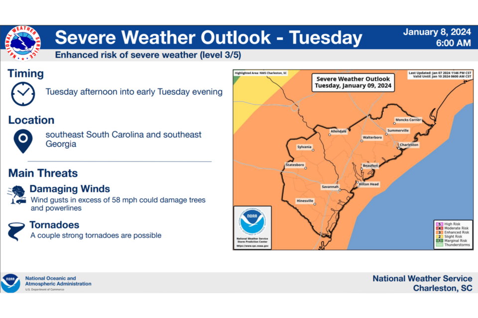
A line of showers and thunderstorms is expected to move through the area on Tuesday. Some of the storms could become severe with damaging wind gusts and isolated tornadoes.
WIND ADVISORY REMAINS IN EFFECT FROM 6 AM TO 10 PM EST TUESDAY
WHAT...South winds 25 to 35 mph with gusts up to 45 mph expected.
WHERE...Portions of southeast Georgia and southeast South Carolina.
WHEN...From 6 AM to 10 PM EST Tuesday.
IMPACTS...Gusty winds could blow around unsecured objects. Tree limbs could be blown down and a few power outages may result.
Key Messages
➔ Severe Weather: Strong to severe thunderstorms are possible Tuesday afternoon into early Tuesday evening (Noon to 8 PM greatest risk. Main hazards are damaging wind gusts and tornadoes.
➔ Winds: Strong southerly winds will develop on Tuesday and could result in downed trees and power outages. Strongest winds along the coast.
➔ Marine: Dangerous marine conditions with wind gusts of 50 knots or greater and seas as high as 10-17 feet expected Tuesday.
➔ High Surf: Large breaking waves will impact the beaches late Monday night into Wednesday morning. High Surf Advisory could be needed.
➔ Coastal Flooding: Minor to moderate coastal flooding is possible with the Tuesday morning high tide.


