
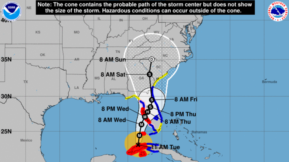
Overview: On Tuesday afternoon, September 27, 2022 Ian is a Category 3 hurricane with maximum sustained winds of 115 mph. It is moving to the north at 10 mph as it exits the northwestern coast of Cuba. Further strengthening is expected today over the southeastern Gulf of Mexico, with maximum sustained winds forecast to reach 130 mph, the lower limit of Category 4 status.
A slow weakening trend will begin tomorrow and continue through landfall. The forecast track has shifted eastward since yesterday, and Ian is now forecast to make landfall over west-central Florida tomorrow and Thursday as a dangerous Category 3 hurricane. Ian’s forward motion will decrease tomorrow and Thursday before picking up speed to the north on Friday. Ian will rapidly weaken Thursday night and Friday and is expected to impact Georgia as a tropical storm on Friday and Saturday before exiting the state on Sunday. There is still uncertainty in the exact track forecast on Friday into the weekend, and a shift to the west or east would translate the highest impacts as well. Heavy rainfall and damaging winds will be possible across Georgia on Friday and Saturday.
Timing: Lighter rain and gusty winds could begin to move into southeastern Georgia on Thursday, but heavier rain bands and potentially damaging winds will likely move in on Friday and overspread Georgia from southeast to northwest throughout the day. North and Central Georgia could see heavy rain and damaging winds Friday night through Saturday before the system moves out on Sunday.
Statewide Impacts
• Tropical storm force sustained winds of over 40 mph with higher gusts will be possible across all of Georgia on Friday and Saturday. The wind field will expand as the storm weakens and moves northward, and damaging winds will be possible statewide, even well away from the center of the track. Downed trees and powerlines are possible statewide on Friday and Saturday.
• Heavy rain is expected on Friday and Saturday, generally overspreading Georgia from southeast to northwest. Widespread rainfall amounts of 2 to 4 inches are possible statewide, with 4 to 6 inches (isolated 8+ inches) forecast in Southeast Georgia. Flash flooding will be possible where heavy rainfall occurs, especially in Southeast Georgia.
Coastal Impacts
Strong onshore flow beginning tomorrow and continuing through Saturday could bring significant coastal impacts. A Storm Surge Watch has been issued for the entire Georgia coast. A Tropical Storm Warning has been issued for Camden and Glynn counties, and a Tropical Storm Watch has been issued for the remainder of the Georgia coast.
Tropical storm conditions will be possible along the entire coastline of Georgia tomorrow through Saturday, with moderate to perhaps major coastal flooding, dangerous rip currents, high surf, and beach erosion all possible. Peak sustained winds of 35-45 mph with gusts up to 65 mph will be possible. 3 to 5 feet of storm surge above ground level will be possible in surge prone areas along the entire Georgia coast. 6 to 8 inches of rainfall in Southeast Georgia could exacerbate any flooding issues that develop.
NWS Charleston Continuous Updates
Follow and Subscribe to Grice Connect Now
Now is the time to be thinking about your Hurricane preparation plans which include liking and following Grice Connect on Facebook and subscribing to Grice Connect daily emails so you can keep up with how this storm could impact Statesboro and Bulloch County.

For more hyper-local Statesboro, Georgia Southern, and Bulloch County news and events delivered directly to your inbox every day, subscribe to Grice Connect's Bulloch Daily email by clicking here. Totally FREE and ALL LOCAL! Unsubscribe at anytime.


