According to Bulloch County Public Safety Director Ted Wynn, it is looking more like Tropical Storm Isaias will remain offshore with most of the bad weather along the coast.
This from Will Lanxton the Georgia State Meteorologist:
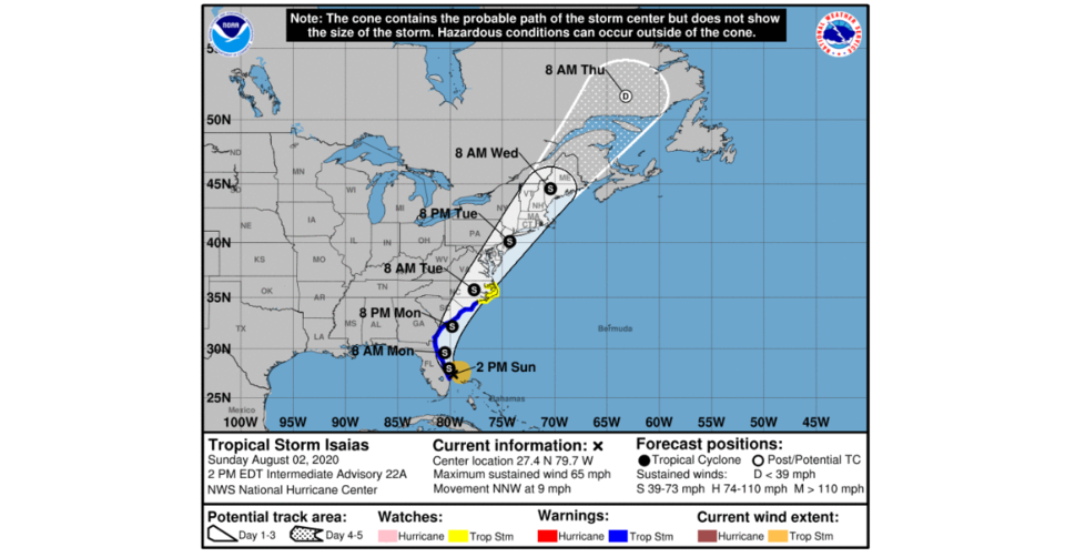
The center of Tropical Storm Isaias is just off the coast of Southeast Florida and has maximum sustained winds of 65 mph. It did not show any signs of re-organizing overnight, and therefore it appears that the window of opportunity for it to re-strengthen is closing. The National Hurricane Center intensity forecast shows little change in strength today and tomorrow. Isaias is expected to closely approach and impact the Georgia coast on Monday (tomorrow). However, the probability of tropical storm force winds along the Georgia coast remains approximately 10-30%.
A Tropical Storm Warning has been issued for the entire Georgia coast. The lopsided nature of the storm will keep the brunt of the impacts offshore, but minor to moderate impacts are possible along the immediate Georgia coast. The weaker/more inland scenario described yesterday is what has occurred. Therefore the center of Tropical Storm Isaias will move closer to the Georgia coast tomorrow, but as a much weaker system than previously forecast. This will not change the expected impacts very much, but it does decrease the likelihood of a worst-case scenario.
Impacts expected along the immediate Georgia coast tomorrow:
• Dangerous and life-threatening marine conditions and rip currents
• Tropical storm force wind gusts of 39 mph or greater are possible
• 1-3 feet of storm surge
• 1-3 inches of rainfall
Timing: Impacts could begin in Camden County around 8 AM Monday. These impacts could continue in any one place along the Georgia coast for 6-12 hours. The system should exit Chatham County around 8 PM Monday. Therefore, it appears that this system will impact the Georgia coast from approximately 8 AM to 8 PM Monday.
For updated information you can view the NWS Charleston Website here.